Day Total - 46.3 miles
Trip Total - 1,454.2 miles
Vancouver. The End.
On the final day of the trip, the weather certainly didn't disappoint. It was raining pretty heavily when I woke up, and though it stopped and started a few times, it didn't look like it was going to stop for good anytime soon. I delayed as long as I could, did a little bit of bike work, and finally I rode off into the drizzle a bit after 10 AM. I chose to deviate from the ACA route and cross the border at the Peace Arch, where I-5 goes into Canada. Of course, I couldn't get on the interstate directly - I had to go through Peace Arch State Park to access the pedestrian/bicycle crossing.
As usual, I got a lot of hassle from the Canadian authorities. The initial border guard had me go inside the customs building to talk to another guard. She didn't give a reason, but the man I spoke with inside seemed very concerned that I was going to try to get a job in Canada despite my assurances otherwise. Somewhat surprisingly, they didn't seem too experienced with cycle tourists at this crossing, perhaps because the ACA sends riders to the truck crossing a few miles to the east.
Wednesday, June 13, 2012
Tuesday, June 12, 2012
Day 36 - Oak Harbor, WA to Blaine, WA
Day Total - 73.4 miles
Trip Total - 1,407.9 miles
Spending the night in the last town before the border. Also, Washington dogs didn't let me down in their last hurrah: I had to fend off a pack of 5 late in the day.
This morning Kevin and I parted ways. We would be following the same route to Bellingham, but I had a lot farther to go than he did. I was trying to get as close to the border as possible, which meant at least 25 miles past Bellingham, so I needed to get an early start. Therefore, at 9 AM, we said our goodbyes and I pedaled north on Highway 20.
Almost immediately, I encountered trouble. Just two miles in, I came to the Deception Pass Bridge. It was built in two sections, with a rocky islet in the middle, and it's also exceptionally narrow with no shoulder. I decided to walk my bike, but as I tried to go across the northern section, I hit a snag. The barriers separating the sidewalk from the road were so close to the railing on the side of the bridge that I couldn't fit my bike through! I had to go all the way back to the southern end of the bridge and ride across it, because the barriers prevented me from entering the road anywhere else. I waited for a break in traffic, then gunned it while taking the middle of the right lane (it would be a lot more dangerous if I stuck to the far right and a car tried to pass). Fortunately, the bridge was only about 3/4 of a mile long, but it was harrowing nonetheless.
Monday, June 11, 2012
Day 35 - Poulsbo, WA to Oak Harbor, WA
Day Total - 59.7 miles
Trip Total - 1,334.5 miles
We saw Canada for the first time today.
In related news, Kevin isn't going to Vancouver. He has decided to end his tour in Bellingham tomorrow, so I'll be going solo north from there.
We started the day at about 10:00 on the very busy Highway 3, which we followed a few miles to the Hood Canal Bridge. The crossing was gorgeous. heading west from the Kitsap to the Olympic Peninsula (and Jefferson County), we could see the snowy Olympic peaks against the clear, blue sky. The weather was the best we have had in Washington so far, and that was good, because we had some 60 miles to ride to our destination for the day.


Sunday, June 10, 2012
Day 34 - Belfair, WA to Poulsbo, WA
Day Total - 40.1 miles
Trip Total - 1,274.8 miles
We got a relatively late start this morning, since today was slated to be a relatively short one by our new, high-mileage Washington standards. Partly because the terrain is much flatter and partly because we haven't had any serious headwinds, our speed in Washington has been much quicker than in Oregon and California. Thus, while a 40 mile day was about average there, it's on the low end for Washington (weather notwithstanding).
We backtracked three miles to the city of Belfair with ambulances and sheriffs speeding by in the other direction. We guessed that it had something to do with the race track down the road, but we never found out for sure. Once we got back to town, we turned onto the Old Belfair Highway, the alternate route to busy Highway 3. This was a really good road, particularly once traffic died down a few miles out of town. It was climbing gradually up the Union River Valley, but not at a steep enough grade to really slow us down. Soon enough, we crossed into Kitsap County, where we would be spending the rest of the day.
Saturday, June 9, 2012
Day 33 - Elma, WA to Belfair, WA
Day Total - 56.4 miles
Trip Total - 1,234.7 miles
Dear Washington dog owners:
When your dog stands in the road barking at us and then charges me, I will pepper spray it. It is not my fault that the dog attacked me. Perhaps you should keep your animals under control - California and Oregon seem to have it figured out, why can't you?
We had to leave the hostel by 9:30 this morning, so we got up at 7:30 to make breakfast in the kitchen. It's the first and likely last time we'll be using an actual kitchen during the trip, and having a real stove was much quicker than the usual camp stove ordeal. We left just after 9:00, but instead of backtracking almost 2 miles to the Adventure Cycling route, we followed the suggestion of the hostel owner and cut off some distance by simply getting on the road north at a different place.
Friday, June 8, 2012
Day 32 - Centralia, WA to Elma, WA
Day Total - 36.7 miles
Trip Total - 1,178.3 miles
It was raining again when we woke up this morning. We waited it out as usual, which was fine, because we had another short day. We were basically going to finish what we would have done the day before had it not been for the weather. In addition, a quick check of the Google maps topo revealed a very flat route. We were folliwng the broad Chehalis River Valley down to the town of Elma, about 35 miles to the northwest.
We walked over to Jack in the Box for breakfast, at which point the rain started again, so we waited in the room until the last possible moment before leaving. At the noon checkout time, we left down the busy main road out of Centralia. Google didn't lie - it was very flat, not to mention we had a tailwind early on.
Thursday, June 7, 2012
Day 31 - Toledo, WA to Centralia, WA
Day Total - 24.8 miles
Trip Total - 1,141.6 miles
Rain-shortened day. No dog chases though.
When we woke up this morning, it was raining. Hard. That's pretty much what the forecast said would happen, and it was immediately clear that we weren't going to be able to do the 60 miles we had planned. So I got back in my tent (Kevin had never left his) and read my book until around 9:30. By then, the rain had become less severe, although it hadn't stopped. I figured that it was a good time to get packed up so that we could leave once the rain stopped. Kevin had other ideas though. He, as usual, wouldn't get out of his sleeping bag, which rendered my plans pointless (in fairness, they weren't necessary either).
The rain finally stopped at about 10:30, at which point I just needed to take my tent down to be ready to go. Kevin, in the meantime, got up at 11. By the time he was ready, another band of precipitation was hitting us, so we didn't end up leaving until 1:15 in the afternoon. We were only going as far as Centralia, a little over 20 miles away though, so time wasn't really a serious issue.
Wednesday, June 6, 2012
Day 30 - Cathlamet, WA to Toledo, WA
Day Total - 48.7 miles
Trip Total - 1,116.8 miles
Today started easily enough, as we pulled out of camp around 10:00 onto a very flat Highway 4. We made great time upriver for the first 10 miles, despite Kevin's bike continuing to cause him problems. It worked well enough to survive the lumber trucks rushing by us though, and not much more than 45 minutes after starting, we turned onto Coal Creek Road into the hills.

This too seemed to be easy until we got to the village of Coal Creek. The problem here wasn't the road or traffic or weather though. It was dogs. All through town, dogs were barking aggressively at us, until on our way out, one got free. It ran into the road after me, of course as I hit a fairly steep section of hill. I was ready though. I had my pepper spray out, and with a flick of the safety and a quick mist, that angry dog was stopped in its tracks. I quickly left the scene as Fido went to go rub his head in the grass for a couple hours. Scoreboard: Cyclists 1, Dogs 0.
Trip Total - 1,116.8 miles
Today started easily enough, as we pulled out of camp around 10:00 onto a very flat Highway 4. We made great time upriver for the first 10 miles, despite Kevin's bike continuing to cause him problems. It worked well enough to survive the lumber trucks rushing by us though, and not much more than 45 minutes after starting, we turned onto Coal Creek Road into the hills.
This too seemed to be easy until we got to the village of Coal Creek. The problem here wasn't the road or traffic or weather though. It was dogs. All through town, dogs were barking aggressively at us, until on our way out, one got free. It ran into the road after me, of course as I hit a fairly steep section of hill. I was ready though. I had my pepper spray out, and with a flick of the safety and a quick mist, that angry dog was stopped in its tracks. I quickly left the scene as Fido went to go rub his head in the grass for a couple hours. Scoreboard: Cyclists 1, Dogs 0.
Tuesday, June 5, 2012
Day 29 - Astoria, OR to Cathlamet, WA
Day Total - 42.1 miles
Trip Total - 1,068.1 miles
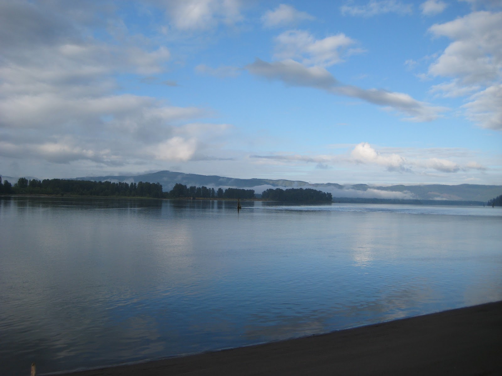
We're camping less than 10 yards from the Columbia River.
We got out of the motel on the late side, around 10:30 in the morning. The weather looked good though, with scattered non-threatening clouds and a nice westerly wind for our eastward jaunt up the Columbia River. Getting out of Astoria was not as pleasant, however. Narrow streets with lots of traffic made the first couple miles a white-knuckle affair. Everyone was driving slowly though, so we got through without any serious scares. On our way out of town, we stopped at Safeway for groceries, which took a good half hour. With that out of the way, we pedaled east on US Route 30.
It wasn't long before we stopped again. Kevin was getting serious play in his cranks, so he stopped to try to fix the problem. At first, he thought he had a loose cassette, so he removed the rear wheel and tried to tighten it. That turned out not to be the problem though, so he tried tightening his pedals. It seemed to work, or at least lessen the problem, so we were on our way after a 45 minute stop.
Trip Total - 1,068.1 miles
We're camping less than 10 yards from the Columbia River.
We got out of the motel on the late side, around 10:30 in the morning. The weather looked good though, with scattered non-threatening clouds and a nice westerly wind for our eastward jaunt up the Columbia River. Getting out of Astoria was not as pleasant, however. Narrow streets with lots of traffic made the first couple miles a white-knuckle affair. Everyone was driving slowly though, so we got through without any serious scares. On our way out of town, we stopped at Safeway for groceries, which took a good half hour. With that out of the way, we pedaled east on US Route 30.
It wasn't long before we stopped again. Kevin was getting serious play in his cranks, so he stopped to try to fix the problem. At first, he thought he had a loose cassette, so he removed the rear wheel and tried to tighten it. That turned out not to be the problem though, so he tried tightening his pedals. It seemed to work, or at least lessen the problem, so we were on our way after a 45 minute stop.

Monday, June 4, 2012
Day 28 - Rest Day, Astoria, OR
We took the day off in view of the weather forecast - heavy rain all day. We got up at 9 and got breakfast in the hotel lobby. Kevin went to the hot tub while I just rested in the room, taking full advantage of the rare opportunity to lay in an actual bed. In the afternoon, we did a much-needed load of laundry. But all through this time, it didn't rain. We don't know what the weather was up the Columbia River, but we easily could have ridden today if the weather was anything like it was in Astoria.
That being said, having two nights in a motel is really what we need at this point. As much as I'm enjoying the tour, it is very nice to spend time in an actual bed, watching television, doing normal things. Plus, as we approach the end of the tour, I have to begin thinking about what I'm going to do afterward.
That being said, having two nights in a motel is really what we need at this point. As much as I'm enjoying the tour, it is very nice to spend time in an actual bed, watching television, doing normal things. Plus, as we approach the end of the tour, I have to begin thinking about what I'm going to do afterward.
Sunday, June 3, 2012
Day 27 - Manzanita, OR to Astoria, OR
Day Total - 47.7 miles
Trip Total - 1,026.0 miles
One thousand miles.
We tried to get an early start this morning to beat the rain that was (as usual) expected to start late in the day, as well as to avoid the Sunday RV traffic. Because we had some bike maintenance to do, however, we didn't get out of camp until close to 10:00. We pedaled back to 101, where we immediately started a steep climb up the cliffs we had seen at the north end of Nehalem Bay the day before. At the top, we stopped and looked back south. We could still see the Three Arch Rocks, which first became visible to us from Cape Lookout two days earlier. We also had an excellent view to the south over Nehalem Bay.

From the viewpoint, we dropped back down into Oswald West State Park, where we were slightly inland under dense forest cover. There was no rest for us, however. As much as I would have loved to stop and hike around a bit, it wasn't in the cards today and we started up another climb almost identical to the first. By this point in the trip though, we both had little trouble sustaining a comfortable pace over long climbs. We reached the top with no trouble, then, after entering Clatsop County, started the steep descent down to the Arch Cape Tunnel. It was a good thing traffic was still light when we went through, because there was absolutely no way that a car could safely pass a bike inside, and that wouldn't have stopped drivers from trying.
Saturday, June 2, 2012
Day 26 - Netarts, OR to Manzanita, OR
Day Total - 49.9 miles
Trip Total - 978.3 miles
When I first woke up at 6, it was raining. I went back to sleep, awoke an hour later, and it was still raining. Same thing at 8. Finally, around 9:30, the sky began to clear, and we got ready to get on our way. Of course, while I had been packing everything I could in my tent, Kevin had decided it was too cold to get out of his sleeping bag, so he wasn't ready until noon. At least the sun had come out by then.
The day's route would be rather circuitous. We wouldn't be going all that far as the crow flies, a little over 20 miles, but the riding distance was close to 50. The reason was that we would first be taking the long way to Tillamook on the Three Capes Route, then we had to go around Tillamook and Nehalem Bays. We could have cut out about eight miles by taking the highway directly from Netarts, the first town of the day, to Tillamook instead of the Cape Meares road, but where's the fun in that?
Trip Total - 978.3 miles
When I first woke up at 6, it was raining. I went back to sleep, awoke an hour later, and it was still raining. Same thing at 8. Finally, around 9:30, the sky began to clear, and we got ready to get on our way. Of course, while I had been packing everything I could in my tent, Kevin had decided it was too cold to get out of his sleeping bag, so he wasn't ready until noon. At least the sun had come out by then.
 |
| It cleared up a little bit overnight |
Friday, June 1, 2012
Day 25 - Lincoln City, OR to Netarts, OR
Day Total - 45.3 miles
Trip Total - 928.4 miles
Good: tailwind
Bad: rain
Ugly: fog
We go up early this morning to try to beat the rain that was forecast to move in by the afternoon. When I looked up the weather on my phone though, the situation got more complicated. The timing of the rain had been moved up, so that we would be lucky to stay out of it even if we did bike as fast as possible. That being said, neither one of us wanted to stay in Lincoln City another night, so we made the decision to go for it.
The sky was overcast when we left, but it was a relatively warm morning again. As a result, we were both quite comfortable during the early part of the ride. We backtracked a mile or so from camp to pick up the Adventure Cycling route around the east side of Devil's Lake. That enabled us to avoid the remainder of Lincoln City and its heavy traffic. East Devil's Lake Road was nice for riding too, pleasantly rolling and quiet, as opposed to the busy strip malls on 101.
Subscribe to:
Posts (Atom)