Thursday, May 31, 2012

Day 24 - Newport, OR to Lincoln City, OR

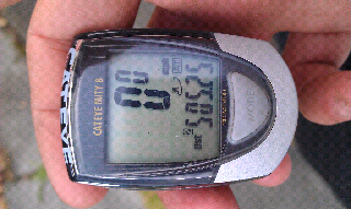
Day Total - 31.9 miles
Trip Total - 883.1 miles

We only had a short day of riding today, dictated by the locations of campgrounds along the coast. Because of that, we didn't have any real reason to get on the road until early afternoon. I went into town at about 10:00 to hang out at the bike shop while Kevin slept in a bit. I met the Starving Cyclist there. He was working on building a new wheel to replace one that was severely cracked. We talked for awhile before I headed inside to use the internet. Kevin, meanwhile, went to the library. He was supposed to meet me at noon, but he got lost in town before a stop at Subway. Because of that, we didn't end up leaving Newport until about 1:00.


We followed side roads along the beach until we were finally forced to rejoin 101 just inside the northern limits of Newport. Traffic was heavy, but good shoulders made it bearable, and the weather was great for riding. It was partly cloudy and in the mid-60s, not to mention dry, which made it better than the average day.

Day 23 - Rest Day, Newport, OR

Having learned our lesson at the last campground, we found a suitable tree from which to hang our food, so we avoided raccoon problems for at least one night. We had decided a couple days back to make this a rest day, so I slept in until about 9:00. I made a quick breakfast before getting on my bike and heading across the Yaquina Bay Bridge into Newport. The bridge has warning lights so drivers are (hopefully) aware that bikes are on the bridge, but even so, I can guarantee that I won't be riding over it again. The combination of Highway 101 and being in a decent sized town makes the lack of a shoulder rather terrifying.

Tuesday, May 29, 2012

Day 22 - Searose Beach, OR to Newport, OR

Day Total - 35.1 miles
Trip Total - 851.2 miles

I woke up early this morning. Very early, in fact, at about 1:30 AM to the sound of rustling plastic bags. My first thought was that a mouse had gotten into my tent, so I tried to flush it out by moving the bags around. Nothing was there though, so I tried to get back to sleep. Then it started again, but I still didn't see anything.

Then, finally, after a third time, I saw it - a raccoon had torn a hold in the side of my tent and was reaching into my food bag, which I had stupidly left out of a pannier and right against the side of the tent. Fortunately, the raccoon hadn't actually gotten anything more than an arm into the tent, but it had ripped open a packet of ramen. I immediately went to Kevin's tent to get duct tape and patch up the hole. I also put my food back inside a pannier, squarely in the middle of the tent, which seemed to be as effective a deterrent as I could muster. The raccoon didn't cause any more trouble for me after that, although I did find out the next morning that he had also gotten into the food of the couple camping next to us.

Day 21 - Winchester Bay, OR to Searose Beach, OR

Day Total - 43.2 miles
Trip Total - 816.1 miles
Lesson of the day: repairs are best left to those who know what they're doing.

Kevin really didn't want to get up this morning. We had agreed the night before to stay in bed if it was raining, which is was very early in the morning. But, because we were under a canopy of pine trees, water continued to drip on our tents long after the rain stopped. I got up at 8:30 and tried to get Kevin out of bed so that we could leave by 11. But he insisted it was still raining! Now, he and I have the same tent, and you can't see outside of them. Even so, he continued to claim that he could tell it was raining, even though I was standing outside with nothing falling on me when I wasn't under a tree. Finally, after a little more grumbling, he got up (once I had breakfast ready, of course).

Unsurprisingly, I was ready to leave well before Kevin. I decided to try my hand at fixing my front brake, which was failing to rebound enough and thus sometimes rubbing against the rim. I knew I just needed to increase the spring tension, but the bolt that seemed to adjust it wouldn't bring it high enough. Then, suddenly, the bolt popped out when I was tightening it. I had stripped the thread on the adjuster, which meant there was now no tension at all and the brake was permanently pressed against the rim.

Sunday, May 27, 2012

Day 20 - Bandon, OR to Winchester Bay, OR

Day Total - 48.3 miles
Trip Total - 772.9 miles
Cruising speed with a tailwind: 17 mph.

We were, unusually, the first bikers out of camp this morning at about 9:15. The forecast said there was a 30% chance of rain, so we wanted to have time to make camp nearly 50 miles away in case we had to take shelter. We left the very busy campground on 101, but just a few miles down the highway, we turned onto Seven Devils Road, the apparently more scenic route recommended by both the ACA and the official state route.

The scenery, though, mostly consisted of logging land, including several clear cut sections. It was definitely an up close and personal reminder of where our lumber and paper comes from, with almost every inch of the roadside showing some evidence of logging activity. At least the road itself was excellent for the most part. There was very little traffic, and much of the road was newly paved. Even the long but shallow climb at the start was pleasant in the shade of the pines (except where those pines had been stripped away, of course).

Saturday, May 26, 2012

Day 19 - Port Orford, OR to Bandon, OR

Day Total - 43.2 miles
Trip Total - 724.6 miles

Getting on the move this morning was tough. It was even wetter than usual, not to mention our hard day into the wind yesterday. We still made it out of camp by 10:15 though, and with only about 40 miles to the next campsite, we had plenty of time.

It was cool and cloudy as we pedaled the six miles to Port Orford, the first town of the day. We made a short side trip to the harbor. Port Orford is a fishing town without any natural protection from the open ocean, so two large cranes lift every boat into and out of the water every day. From there, we continued north out of town, but not before Kevin's coffee stop at a Circle K (weirdly, just a store, not a gas station). While he was inside, I talked to a woman outside and horrified her with the sunburn on my legs.

Day 18 - Brookings, OR to Port Orford, OR

Day Total - 54.6 miles
Trip Total - 681.4 miles
Reason #286 not to go north: Southbounders going faster up the hill than you're going down it.

The air was chilly and the skies ominous when we woke up this morning. The forecast called for strong headwinds, but we weren't feeling much in the campground. As we ate breakfast though, the trees began to move just a bit. Then more and more. By the time we left around 9:30, we knew we were in for a tough day.

The root of the problem wasn't so much the wind as campsite location. The next hiker/biker camp was 53 miles to the north at Humbug Mountain State Park, so that was, barring a stop at a motel or an RV park, our only real option. As we got on the road, traffic was fairly heavy, but it dropped off quickly as we got away from Brookings. Most of the first 15 miles was through Samuel Boardman State Park, where there are frequent scenic viewpoints along the coast. I stopped at a couple, much to Kevin's consternation. The wind wasn't getting any lighter, and the clouds to the north looked worse by the minute.

Thursday, May 24, 2012

Day 17 - Rest Day, Brookings, OR

We didn't go anywhere today.

I woke up at 7:30 with the predicted rain falling on my tent. Then I went back to sleep, since it was a rest day, and I didn't get up until 9:30. We had breakfast not long after, then walked down to the beach. We left quickly though, as it was cold and had started to rain again. It was definitely a good day to be off the bikes.

In the early afternoon, we decided to do laundry at the.campground laundromat. The Starving Cyclist had just put his clothes into the washing machine, and he offered to let us use some of his detergent. After that, I took another walk around the park, then returned to camp and cooked a can of ravioli for dinner. It was raining yet again by that point, so I went into the tent and got to work on blog updates. Overall, it was a slow, boring rest day, and that was exactly what we needed.

Wednesday, May 23, 2012

Day 16 - Crescent City, CA to Brookings, OR

Day Total - 44.1 miles
Trip Total - 626.9 miles

The morning was, unusually, quite warm. Kevin was very slow to get going though, and it took a full three hours to get out of camp. We began the day by climbing back up to the highway, which, at 500 feet above camp, definitely gave us a good warmup. Once we got to 101 though, we had a huge descent in front of us. It was 1200 feet down into Crescent City at an 8% grade. We covered the remaining 7 miles to town in a little over 20 minutes, even with a headwind slowing us down.

In Crescent City, Kevin again wanted fast food, and again, the place he wanted to go, Jack in the Box, was closed. We settled for Burger King, and after a nice calorie stop, we were on our way around noon. We cut west back to the ACA route along the coastline and away from 101. We would mostly avoid the highway for the rest of the day. The coastline at Crescent City looked a lot like Oregon's, by now less than 30 miles away, and we had gorgeous views of waves crashing against massive rocks before we turned back inland.


Update From The Road


Day 15 - Orick, CA to Crescent City, CA

Day Total - 36.8 miles
Trip Total - 582.7 miles

We're actually about 8 miles short of Crescent City, but towns are getting few and far between.

Getting out of bed today was difficult, not because it was cold or because we were especially tired, but because we were getting out of actual here. A little after 8, I finally got up and took a nice, hot shower before running across the street to the Orick Market to grab breakfast. Outside, it was still damp, but at least it wasn't raining.

Morning in Orick
Shortly after we got back to the room, I noticed someone grabbing things from right outside our window. Kevin had left his sleeping pad and a few other items out the night before, and he went out to see if the man was taking them. They were about to pull away when Kevin went up to them to get his stuff back - they apparently thought another group had left it there.

Monday, May 21, 2012

Day 14 - Arcata, CA to Orick, CA

Day Total - 40.6 miles
Trip Total - 545.9 miles

The forecast for the day called for rain, but with a tailwind also in the forecast, we hoped to be able to make the 45 miles to Prairie Creek Redwoods State Park. The weather was actually quite pleasant when we left, and we initially just rode around.town running a few errands. After grocery and bike shop stops, we got on the road toward McKinleyville. The back roads took us through dairy country again, with the same strong west winds we had the day before.


Once into town, we got onto the Hammond Trail, a local coastal bike path. We followed it for about 4 miles before briefly rejoining 101. After a hill climb, we exited onto Scenic Dr., a rough, narrow road on the shoreline bluffs. The views were spectacular though, and we wound along the cliffs into Trinidad. By now, a light drizzle was coming down. It wasn't affecting riding conditions, however, so we continued on toward Patrick's Point State Park.

Sunday, May 20, 2012

Day 13 - Weott, CA to Arcata, CA

Day Total - 66.0 miles
Trip Total - 505.3 miles
500 miles! Also, solar eclipse!


We began the day on the Avenue of the Giants. It was still cool in the shade of the redwoods, but once we got a bit further north, the trees thinned out and the jackets came off. the road was extremely flat, even slightly downhill, and after about 15 quick miles, we reached the northern terminus of the Avenue of the Giants.

After a brief snack stop, we rejoined 101 for a few miles. On the long freeway straights, we battled a stiff headwind, but at least we had a wide shoulder. A few miles later, in the timber mill town of Scotia, we exited 101 for side roads. After crossing the Eel River into Rio Dell, we turned onto a back road. Though short, the climbs on this road were exceptionally steep. Combined with the extremely poor conditon of the roads, it was slow going through this section.

Saturday, May 19, 2012

Day 12 - Leggett, CA to Weott, CA

Day Total - 50.8 miles
Trip Total - 439.2 miles
Tonight, we sleep among the giants.


With the Leggett Hill out of the way, we were rewarded with a two-day downhill with only minor climbs. And while the hill had tested how far we have come in climbing ability, today would be the test of putting distance behind us. It is about 50 miles between our starting point just north of Leggett and our target just south of Weott along the Avenue of the Giants.

Today's inland route (in fact, the first and likely only day of the trip where we did not see the ocean at all) meant a much warmer morning than we would have had on the coast. We made breakfast and packed up, and we were on our way out soon after 9:30. It was a bit of a nervous start for Kevin - he had ripped one of his rear pannier hooks off trying to get into the campground the night before, and the first few miles would test how his duct tape-repaired system would work.

Day 11 - Westport, CA to Leggett, CA

Day Total - 31.8 miles
Trip Total - 388.4 miles

We woke up to a very cold morning, in the low 40s at most. We had a bit of bike maintenance to do before leaving, so after cleaning and living our chains and making another attempt to secure my front rack, we were on our way at about 10:30.

A couple miles out of camp, we discovered that we were wrong about Westport State Beach being closed. The first campground we came to was, but a little further down the road, the main campground was very much open. It still wasn't sheltered at all though, so everything probably worked out for the best.

Meanwhile, the clear skies allowed the temperature to rise to a comfortable 55-60 degrees as we rode along the coast. The views northward toward the extremely rugged Lost Coast were spectacular, but they didn't last long. About 7 miles into the ride, we left the shoreline and climbed 600 feet through forest. That climb was just an appetizer though, as it would be followed by the main course for the day - 1600 feet up Leggett Hill.

Goodbye Ocean.

Thursday, May 17, 2012

Day 10 - Mendocino, CA to Westport, CA

Day Total - 31.7 miles
Trip Total - 356.6 miles

Tomorrow is the biggest climb of the trip and the end of Highway 1.

We pulled out of camp at 9:30, fortunately without having to pull any more banana slugs out of our food locker, and were once again on our way northward. Today wasn't going to be strenuous though - after the first 8 miles into Fort Bragg, we stopped for a few hours to do laundry. While there, Kevin called his friends Dylan and Katie, who happened to be in town. They drove down to the laundromat, and once our clothes were dry, they had lunch with us at the Mexican restaurant next door. Kevin and I both had massive and delicious burritos before we left to do a bit of shopping.

After grabbing food at Safeway and more stove fuel at The Outdoor Store, we turned off Highway 1 at the north end of town. The ACA route put us on a bike path called the Ten Mile Beach Trail, which turned out to be the worst bike path I've ever seen. We got tossed around by potholes within potholes for 3 miles, and I had to stop a couple of times to keep my front rack from falling off the bike. I can't imagine that dealing with the much-diminished traffic on Highway 1 would have been worse. The path ended at an unsigned drop back onto the road. We only figured it out because the next bridge was demolished.

Day 9 - Rest Day, Mendocino, CA

Day Total - 5.8 miles
Trip Total - 324.9 miles

And on the ninth day, we rested.

We slept in very late, by our standards anyway, made breakfast, and instead of loading up the bikes, we just relaxed. Kevin read his book, I walked around Russian Gulch State Park, where we were camped, and we just stayed away from the bikes.

At around 1:00, we biked into town to use the internet at one of the cafes and grab some groceries. We got coffee and sat down outside, where I tried to update my blog. Of course, it being Mendo, there was a crazy old guy there with us (actually two,but only one was notable). He told us about how he travelled the world for 8 years,how you can get a $10 pint of whiskey at Safeway, how he travelled the world for 8 years, how he eats only peanut butter and hot sauce, and how you can get a $10 pint of whiskey at Safeway. Also, don't ever tell anyone where your tree is.

Other than that, there wasn't much notable about the day. I took a shower in the morning, increasing my lead over Kevin in that category, but when that counts as exciting, you know it's a nice lazy day.

Pictures after the jump.

Wednesday, May 16, 2012

Day 8 - Manchester, CA to Mendocino, CA

Day Total - 33.2 miles
Trip Total - 319.1 miles

Kevin wanted to take our rest day a day early, but I mixed that idea in view of the exposed campsite, meager facilities, wind, and gophers. We only had about 30 miles to go to the town if Mendocino, which, as a tourist destination, would have quite a bit more for us than sleepy Manchester.

We started the cold, foggy day into a headwind, and perhaps as a result of the temperature, my legs seemed to take forever to warm up. It took 7 or 8 miles of riding to get comfortable. We dropped down a switchbacking grade not long afterward - fortunately, there were none of the lumber trucks that would be passing us all day. The uphill was long, but I have gotten much better at gear selection, so it wasn't much of a problem to get up in one go.

I told you it was foggy.

Monday, May 14, 2012

Day 7 - Fort Ross, CA to Manchester, CA

Day Total - 41.5 miles
Trip Total - 285.9 miles

Today, we had a decision to make - we were desperately in need of a rest day, but we wanted to take it near a town, in this case Mendocino or Fort Bragg. However, they were still over 70 miles away. We could either do two 20 mile days and a 30 miler or cover the first 40 in a single day. The potential extra stop was just south of the town of Gualala, on the Sonoma-Mendocino County line. We agreed that making the decision on the road made sense, and with that we set off from Salt Point at about 10:30.

The first bit of the ride was easy - gently rolling terrain and calm wind meant that we averaged about 12 mph, a speed we would keep up for most of the day. The weather, which had started off cool and foggy, turned very clear by about 11:00, making the ocean on our left a brilliant, shimmering blue.
After passing through the gas station that is Stewarts Point and the 10 mile stretch of vacation homes in The Sea Ranch, we arrived in Gualala at noon. This was our decision point, and though we had kept an extremely fast pace, Kevin and I both agreed that we should go to Manchester. We stopped for about 45 minutes to get food at the largest grocery store we had seen since the Marin suburbs, then continued north.

Now this is a nice road

Day 6 - Bodega Bay, CA to Fort Ross, CA

Day Total - 30.6 miles
Trip Total - 244.4 miles

Even though I had taken a shower at the last campground, the showers at Bodega Dunes were free, so I began the morning with another. This one wasn't quite as warm though - I'm glad I didn't pay for it.
The fog was still sitting over us in the morning, and it was very chilly outside our sleeping bags. Fortunately for us, we could start late, because we had a relatively short 30 mile day in front of us with a stop to watch the first stage of the Tour of California, a professional stage race, as the name suggests, around the state. 

We didn't end up leaving until around 11:30. Once we got on the road, we were passed by packs of cyclists heading south. I guess they were riding the Tour route ahead of the race. The road was back to rolling, but the coast was much different than in Marin County. The coastline itself was mostly low cliffs with rocks jutting out of the water. There also weren't as many trees. Everything appeared windswept, although the air was calm when we passed through.

Saturday, May 12, 2012

Day 5 - Lagunitas, CA to Bodega Bay, CA

Day Total - 44.0 miles
Trip Total - 213.7 miles

We were definitely sluggish in waking up due to the darkness among the towering redwoods of Taylor State Park. The kids weren't though, and a few began their day by racing their bikes down the hill right past our campsite.

We began our day on a bike path, the Cross Marin Trail, that as far as I can tell doesn't extend outside of the park yet. From there, we took back roads toward Point Reyes Station, which was just barely south of our route. We had been passing and been passed by cyclists the whole morning, but Point Reyes Station was entirely taken over by cyclists. It seemed like every bike owner in Marin County decided to come through for a Saturday ride. We only stopped to look for stove fuel, which no one in town had, but it was an amazing sight to see.

Day 4 - Angel Island, CA to Lagunitas, CA

Day Total - 29.3 miles
Trip Total - 169.7 miles

We got up fairly late in the morning, since we couldn't get off the island until 10:30 anyway. After enjoying the view onevlast time over breakfast, we rode back to the ferry dock. On the boat with us were a group of middle schoolers in what appeared to be Civil War garb returning from a camping trip.

We disembarked in Tiburon around 11 (it took awhile until we could get on the ferry because there were so many passengers getting off from San Francisco) and immediately made for the In-N-Out Burger we had passed the previous day. With only minor navigational difficulties, we found it and scarfed down some delicious calories. That's one nice thing about cycle touring - we could eat fast food all the time and still be in good shape.

Thursday, May 10, 2012

Day 3 - Half Moon Bay, CA to Angel Island, CA

Day Total - 48.5 miles
Trip Total - 140.4 miles

We had to catch the Angel Island Ferry in Tiburon at 3 PM. That decided everything else for the day.

We left Half Moon Bay at 7:30 AM, when it was still quite chilly to say the least. The first 10 miles were surprisingly quick - the northerly wind hqd died down and we made good time on the fairly flat road. But then we hit Devil's Slide. Caltrans is building a tunnel to bypass this section, and it's pretty terrifying in a car. On my bike, I got to the point where I no longer felt safe riding, with heavy traffic, a steep grade, and no shoulder. I got off and pushed, keeping the bike between the traffic and me. Finally, I reached the summit, and Kevin and I blasted down the hill into Pacifica at 40 mph. We made a much-needed grocery stop in town and continued on our way.
Just before the road got dangerous

Wednesday, May 9, 2012

Day 2 - Soquel, CA to Half Moon Bay, CA

Day Total - 62.4 miles
Trip Total - 91.9 miles
Headwind all day.  Averaged less than 9 mph.  Physically hardest day of my life.  Held back tears when I saw the "Entering Half Moon Bay" sign.


If yesterday was a relatively easy start to the tour, today showed us just how hard touring can be. The day started with almost 10 miles through the streets of Soquel and Santa Cruz. They weren't much of a challenge apart from the traffic. The ACA route does a good job of sending riders along bike-friendly roads, so we mostly had a bike lane, except on side streets without much traffic anyway.

Farmland north of Santa Cruz
Then, as we left Santa Cruz, it began. The wind blew furiously out of the north. At first we thought it was just a gusty section at the northern end of Monterey Bay, but by the small town of Davenport, it was clear that it wasn't going away. The situation wasn't helped by the terrain - constant rolling hills through Santa Cruz County, with steep climbs of a few hundred feet each coming one after the other. Add to that equation almost no trees and beach traffic and you get miserable riding up to the San Mateo County line.

Tuesday, May 8, 2012

Day 1 - Los Gatos, CA to Soquel, CA

Day Total - 29.5 miles
Trip Total - 29.5 miles

We have arrived at the Pacific Ocean.
The goal for the day was to get up and over the Santa Cruz Mountains from the San Jose area to the Pacific Coast at Soquel. We rode through downtown Los Gatos to the Los Gatos Creek Trail, which we followed up to Lexington Reservoir. As a first loaded climb, it turned out quite well, particularly considering that my bike doesn't get much traction on unpaved surfaces.

Once we reached the top of the dam, we took a rather hot ride around the reservoir - the temperature had risen to 90 degrees. The road was in good shape with little traffic though, and we finally got into the shade on the Old Santa Cruz Highway within a few miles of turning off the lake.

Saturday, May 5, 2012

Huh?

To answer all of your questions (and to put something, anything, on this blog), here's a quick summary of what this thing is going to be about.

What are you doing?
I'm bicycling up the Pacific Coast from Santa Cruz, CA (actually Los Gatos/San Jose initially) to Vancouver, BC.  And maybe further, I don't really know at this point.

That's really far!  How long will that take?
It's somewhere around 1300 miles, which at a pace of around 50 miles a day (very doable on a bike) should take three weeks to a month.

What route are you taking?
It's not completely finalized at this point, but I'll primarily be on California Highway 1 most of the way from Santa Cruz until it ends in northern Mendocino County, and then mostly US 101 from there until Astoria, OR.  After that, I can either go around the Olympic Peninsula in Washington or cut inland for a bit and bike through the islands of Puget Sound.  From there, I'll be heading to Vancouver either directly or via Victoria, BC and Vancouver Island (and a few ferry rides).

Where are you staying?
My tent, most nights.  There might be occasional hostel/motel stops, but those will probably be few and far between.

How are you carrying everything?
My bike has both front and rear racks mounted to it, from which I'll be hanging panniers (that's cyclist for "bags") and strapping down larger items that don't really fit.  I'll get a picture of my bike up here soon that will make that seem a lot less weird than it sounds.

What kind of bike are you riding?
I have a Novara Randonee touring bike, which is basically a steel road bike.  I've pretty much kept the stock configuration (more for reasons of cost than anything else) other than adding fenders and a front rack.  Without getting into too much technical talk, it's a 30 speed bike with 700C wheels and 32mm tires.  It has a longer wheelbase than your average road bike to accommodate the extra weight - the bike itself weighs around 30 pounds, and fully loaded there will be another 40 pounds or so on top of that.  The steel frame makes the bike heavier, but it's much more stable under load than an aluminum bike would be, and plus it absorbs shock better, which is important because the bike has no suspension (racks and suspension don't go together).

Who are you going with?
I'm going with a friend of mine from Kirkwood, Kevin Cage.  He's the cycling mind - I frequently have no idea what I'm doing when I'm working on my bike, while he's been able to solve pretty much all of the issues I've had with my bike so far.

Day 1 of the tour is Tuesday, May 8.  That will be a relatively short ~24 mile ride over the Coast Range to Santa Cruz.  From there, we'll ride about 100 miles over the next two days to get through San Francisco and into Marin County.  We'll hit Point Reyes by the weekend, and then it's up into Sonoma and Mendocino Counties from there.